EXTENSION OF SINCOHMAP PROJECT
The SInCohMap project has served to demonstrate the potential of time series of interferometric coherences derived from Sentinel-1 (S1) data to generate accurate land cover and vegetation-type maps. This has been done over three different test sites (South Tyrol in Italy, Doñana in Spain, and West Wielkopolska in Poland) which are characterised by different classes and geographical features. The results obtained in the SInCohMap project showed the improvement with respect to using only backscatter/intensity data and, in many cases, a better performance of coherence than backscatter/intensity when considered independently. These results have been achieved independently from the classification algorithm employed, since similar performances and improvements were found using different classifiers, and by independent institutions in the course of a Round Robin consultation.
Along with the development of the SInCohMap project, a number of topics were identified for further analysis. They stemmed from the experience acquired during the process, and especially from discussions among members of the consortium and in the progress meetings with ESA. These topics constitute an extension of the original project since their definition was not sufficiently mature at the beginning of the project.
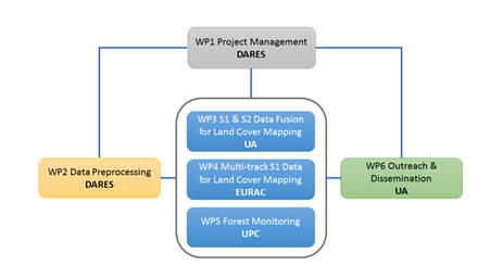
The extension of the SInCohMap Project is carried out by four members of the original consortium: DARES, EURAC, UA, and UPC.
OBJECTIVES
Along with the development of the SInCohMap project, a number of topics were identified for a further analysis. From them, three relevant aspects have been selected and constitute the three main objectives of the project extension.:
- Fusion of S1 interferometric coherence and Sentinel-2 (S2) images for land cover classification.
- Multitrack S1 interferometric coherence for land cover classification.
- Forest classification and monitoring using S1 coherence information.
OVERVIEW
The first two objectives deal with extensions of the observation space, adding S2 images and multi-track S1 data, respectively. They will be tested for data acquired over three years (2017-2019) and with alternative fusion methods, both using all data as input features of the classifier and performing the fusion a posteriori when they are employed as independent input feature sets. The sites to continue this study will be South Tyrol and Doñana.
Regarding the third objective, relevant to forest monitoring, is an exploratory study in search for a forest site in which sufficiently high coherence levels are kept and, therefore, the interferometric information would be exploited for forest type classification and potentially for biophysical parameter retrieval. This sort of study was completely out of the scope of the original scope of the SInCohMap project. Potential candidates to carrier out this study are forest areas in Finland.
Work Package Structure
The project extension is planned for one-year duration. This phase of the project contemplates three main phases: a three-month phase for S1/S2 data preprocessing (WP2), a six-month phase for implementation and validation (WP3, WP4, WP5), and three-month phase for closing final reports and scientific roadmap.